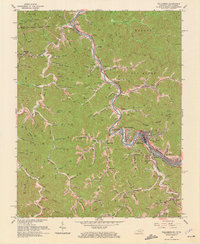
1964 Map of Williamson
USGS Topo · Published 1972About this map
The Tug Fork and Tug River define this borderland landscape, where the coal-driven economy of the mid-1960s is etched into the steep topography of the West Virginia and Kentucky state line. The city of Williamson serves as the regional hub, flanked by industrial and residential pockets like West Williamson, South Williamson, and East Williamson. The Norfolk and Western railroad tracks follow the river's winding course, linking a string of communities including Chattaroy, Nolan, and Borderland. This period of development is characterized by numerous mines and gas wells scattered across the ridges, supported by local institutions such as Whitepost Sch and Turkey Creek Sch. The map records the intricate network of hollows and branches, from Hurricane Branch to Chaffin Branch, that shaped the settlement patterns of families living along the river valley during this era of peak industrial activity.
Find a feature on this map
83 named features on this map. Tap any name to fly to it.
Don’t see what you’re looking for? This feature index may not catch every label — zoom into the map to look around manually.
Map Details
Editions of this 1964 Williamson Map
4 editions found
Other maps of this area

1887 · Warfield
USGS Topo · 1:125,000

1891 · Warfield
USGS Topo · 1:125,000

1909 · Matewan
USGS Topo · 1:48,000

1910 · Holden
USGS Topo · 1:48,000

1910 · Naugatuck
USGS Topo · 1:48,000

1912 · Naugatuck
USGS Topo · 1:62,500

1912 · Holden
USGS Topo · 1:62,500

1915 · Williamson
USGS Topo · 1:48,000

1915 · Naugatuck
USGS Topo · 1:48,000

1915 · Matewan
USGS Topo · 1:48,000