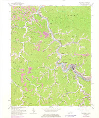
1964 Map of Williamson
USGS Topo · Published 1978About this map
Williamson and its neighboring coalfield communities straddle the Tug Fork river, defining the sharp boundary between West Virginia and Kentucky in the late 1950s and early 1960s. The landscape is a complex network of narrow hollows and steep ridges, where industry and infrastructure are squeezed into the valley floors. The Norfolk and Western railroad snakes through the corridor, serving the intensive extractive operations marked by numerous Strip Mine sites and gas wells.
Find a feature on this map
98 named features on this map. Tap any name to fly to it.
Don’t see what you’re looking for? This feature index may not catch every label — zoom into the map to look around manually.
Map Details
Editions of this 1964 Williamson Map
4 editions found
Other maps of this area

1887 · Warfield
USGS Topo · 1:125,000

1891 · Warfield
USGS Topo · 1:125,000

1909 · Matewan
USGS Topo · 1:48,000

1910 · Holden
USGS Topo · 1:48,000

1910 · Naugatuck
USGS Topo · 1:48,000

1912 · Naugatuck
USGS Topo · 1:62,500

1912 · Holden
USGS Topo · 1:62,500

1915 · Williamson
USGS Topo · 1:48,000

1915 · Naugatuck
USGS Topo · 1:48,000

1915 · Matewan
USGS Topo · 1:48,000