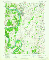
1953 Map of Williamsport
USGS Topo · Published 1965About this map
Williamsport serves as a focal point along the Maryland and West Virginia border, where the meandering Potomac River meets the Conococheague Creek. This mid-century survey illustrates a dense network of transportation infrastructure, including the Chesapeake and Ohio Canal following the river's edge and multiple major rail lines like the Western Maryland and Pennsylvania railroads. The landscape is dotted with small rural communities such as Downsville, Bakersville, and Grimes, reflecting a traditional agricultural and industrial layout.
Find a feature on this map
39 named features on this map. Tap any name to fly to it.
Don’t see what you’re looking for? This feature index may not catch every label — zoom into the map to look around manually.
Map Details
Editions of this 1953 Williamsport Map
4 editions found
Other maps of this area

1884 · Harpers Ferry
USGS Topo · 1:125,000

1891 · Harpers Ferry
USGS Topo · 1:125,000

1893 · Harpers Ferry
USGS Topo · 1:125,000

1908 · Middletown
USGS Topo · 1:48,000

1909 · Hagerstown
USGS Topo · 1:48,000

1910 · Antietam
USGS Topo · 1:62,500

1912 · Hagerstown
USGS Topo · 1:62,500

1912 · Williamsport
USGS Topo · 1:62,500

1914 · Martinsburg
USGS Topo · 1:48,000

1916 · Martinsburg
USGS Topo · 1:62,500