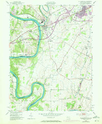
1953 Map of Williamsport
USGS Topo · Published 1972About this map
The Potomac River defines the border between Maryland and West Virginia, winding through deep meanders like Powell Bend and the Neck. The town of Williamsport serves as a central hub, situated where the Conococheague Creek meets the Potomac. This area is a significant transportation corridor, featuring the Chesapeake and Ohio Canal paralleling the riverbank and a dense network of railroads, including the Western Maryland, Penn Central, and Norfolk and Western.
Find a feature on this map
44 named features on this map. Tap any name to fly to it.
Don’t see what you’re looking for? This feature index may not catch every label — zoom into the map to look around manually.
Map Details
Editions of this 1953 Williamsport Map
4 editions found
Other maps of this area

1884 · Harpers Ferry
USGS Topo · 1:125,000

1891 · Harpers Ferry
USGS Topo · 1:125,000

1893 · Harpers Ferry
USGS Topo · 1:125,000

1908 · Middletown
USGS Topo · 1:48,000

1909 · Hagerstown
USGS Topo · 1:48,000

1910 · Antietam
USGS Topo · 1:62,500

1912 · Hagerstown
USGS Topo · 1:62,500

1912 · Williamsport
USGS Topo · 1:62,500

1914 · Martinsburg
USGS Topo · 1:48,000

1916 · Martinsburg
USGS Topo · 1:62,500