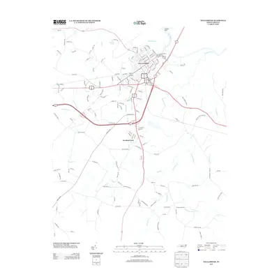
2013 Map of Williamston
USGS Topo · Published 2013About this map
The town of Williamston serves as the central focus of this landscape, situated near a distinctive curve of the Roanoke River known as Conoho Bend. The mapping records a transition from the compact street grid of the town center—including corridors like E Main St and W Church St—to the surrounding agricultural and timbered lands of Martin County. Beyond the town limits, the terrain is defined by a dense network of hydrologic features, including Skewakee Gut and the slow-moving drainage of Back Swamp and Peter Swamp. To the south, the newer residential development of Woodland Acres stands between the town and the rural reaches of Hardison Mill Cr. The map's detail provides a record of the area's modern infrastructure, from the industrial sites near Landfill Rd to the various branches of the Ready Br and Smithwick Cr systems that drain the low-lying coastal plain.
Find a feature on this map
144 named features on this map. Tap any name to fly to it.
Don’t see what you’re looking for? This feature index may not catch every label — zoom into the map to look around manually.
Map Details
Editions of this 2013 Williamston Map
This is the sole edition of this map. No revisions or reprints were ever made.
Other maps of this area

1901 · Williamston
USGS Topo · 1:62,500

1902 · Williamston
USGS Topo · 1:62,500

1903 · Chocowinity
USGS Topo · 1:62,500

1905 · Chocowinity
USGS Topo · 1:62,500

1943 · Plymouth
USGS Topo · 1:125,000

1953 · Rocky Mount
USGS Topo · 1:250,000

1954 · Rocky Mount
USGS Topo · 1:250,000
1978 · Farmlife
USGS Topo · 1:24,000
1978 · Jamesville
USGS Topo · 1:24,000

1978 · Windsor South
USGS Topo · 1:24,000