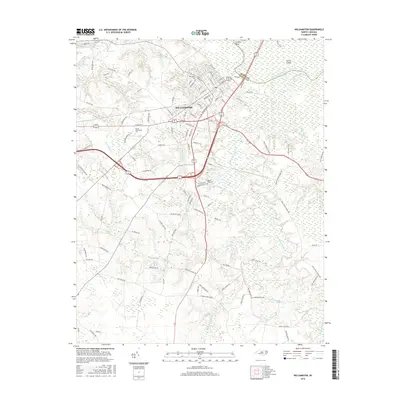
2016 Map of Williamston
USGS Topo · Published 2016About this map
Williamston serves as the focal point of this coastal plain landscape, situated along the southern banks of the Roanoke River. The town's layout reflects its role as a regional hub, with the campus of Martin Community Coll established on the western edge. The riverine environment is well-defined by the wide arc of Conoho Bend and the presence of Conine Island, separating the mainland from the low-lying wetlands of the neighboring county. Local genealogy and history are preserved at sites like Woodlawn Cem near the town center and the Staton-Biggs Cem further south. The surrounding terrain is heavily influenced by drainage systems including Back Swamp and Hardison Mill Cr, illustrating the water-dependent geography of eastern North Carolina in the early twenty-first century.
Find a feature on this map
114 named features on this map. Tap any name to fly to it.
Don’t see what you’re looking for? This feature index may not catch every label — zoom into the map to look around manually.
Map Details
Editions of this 2016 Williamston Map
This is the sole edition of this map. No revisions or reprints were ever made.
Other maps of this area

1901 · Williamston
USGS Topo · 1:62,500

1902 · Williamston
USGS Topo · 1:62,500

1903 · Chocowinity
USGS Topo · 1:62,500

1905 · Chocowinity
USGS Topo · 1:62,500

1943 · Plymouth
USGS Topo · 1:125,000

1953 · Rocky Mount
USGS Topo · 1:250,000

1954 · Rocky Mount
USGS Topo · 1:250,000
1978 · Farmlife
USGS Topo · 1:24,000
1978 · Jamesville
USGS Topo · 1:24,000

1978 · Windsor South
USGS Topo · 1:24,000