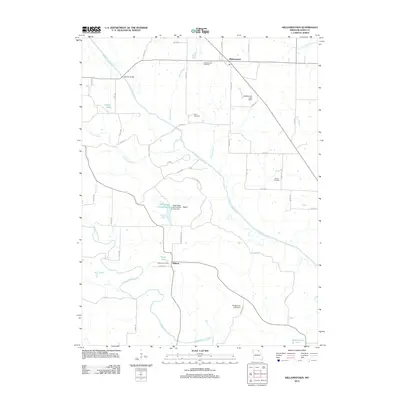
2012 Map of Williamstown
USGS Topo · Published 2012About this map
Williamstown anchors this Lewis County landscape, serving as a primary point of settlement in a region defined by the winding paths of the North Fabius River and the Middle Fabius River. The map reveals a deeply rural character where smaller communities like Egypt and Midway are linked by a network of county roads and named creek branches. Genealogists will find significant value in the distribution of family-named landmarks and local burial sites, including Williamstown Cemetery, Cecil Cemetery, and Morris Cemetery. A substantial portion of the central terrain is dedicated to the Deer Ridge Wildlife Area, which surrounds Deer Ridge Community Lake. This intersection of conservation land, river bottomlands, and small upland settlements illustrates the enduring agricultural and natural heritage of northeast Missouri.
Find a feature on this map
54 named features on this map. Tap any name to fly to it.
Don’t see what you’re looking for? This feature index may not catch every label — zoom into the map to look around manually.
Map Details
Editions of this 2012 Williamstown Map
This is the sole edition of this map. No revisions or reprints were ever made.
Other maps of this area

1903 · Kahoka
USGS Topo · 1:125,000

1949 · St. Patrick
USGS Topo · 1:24,000

1950 · Saint Patrick
USGS Topo · 1:24,000

1950 · Neeper
USGS Topo · 1:24,000

1950 · Benjamin
USGS Topo · 1:24,000

1950 · Williamstown
USGS Topo · 1:24,000

1950 · Lewistown
USGS Topo · 1:24,000

1950 · Colony
USGS Topo · 1:24,000
1950 · Monticello
USGS Topo · 1:24,000

1950 · La Belle
USGS Topo · 1:24,000