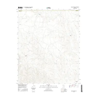
2016 Map of Willow Arroyo
USGS Topo · Published 2016About this map
Palo Duro Canyon carves through the southeastern corner of this landscape, marking a dramatic shift in the terrain where the high plains break into the canyonlands of the Texas Panhandle. This area, surveyed near the Briscoe County borders with Armstrong and Donley counties, is defined by a complex drainage network feeding the Red River watershed. High points like the Stinkhole Divide separate the northern waters of Battle Cr and Love Arroyo from the southern reaches of Hackberry Cr. The cattle-country infrastructure is represented by rural connectors such as Co RD SS, which navigates the draws and ridges surrounding the namesake Willow Arroyo. This survey provides a clear view of the land's transition from flat prairie to the intricate breaks and arroyos typical of the regional escarpment.
Find a feature on this map
12 named features on this map. Tap any name to fly to it.
Don’t see what you’re looking for? This feature index may not catch every label — zoom into the map to look around manually.
Map Details
Editions of this 2016 Willow Arroyo Map
This is the sole edition of this map. No revisions or reprints were ever made.
Other maps of this area

1954 · Plainview
USGS Topo · 1:250,000

1958 · Plainview
USGS Topo · 1:250,000

1960 · Indian Peak
USGS Topo · 1:62,500

1960 · Brice
USGS Topo · 1:62,500

1963 · Paloduro
USGS Topo · 1:24,000

1963 · Tate Arroyo
USGS Topo · 1:24,000

1963 · Clarendon SW
USGS Topo · 1:24,000
1976 · Indian Peak SW
USGS Topo · 1:24,000

1976 · Brice NW
USGS Topo · 1:24,000
1976 · Indian Peak NW
USGS Topo · 1:24,000