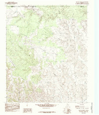
1985 Map of Willow Arroyo
USGS Topo · Published 1985About this map
Stinkhole Divide anchors the central terrain of this Texas Panhandle landscape, where the high plains break into a complex system of drainage and erosion. Located at the intersection of Armstrong, Donley, and Briscoe counties, the area is defined by a series of significant watercourses including Lone Tree Creek and Willow Arroyo. The topography is shaped by the transition toward the dramatic Palo Duro Can, with the land falling away into intricate seasonal creek beds. The presence of numerous corrals and unnamed windmills suggests a landscape primarily dedicated to large-scale ranching and cattle operations. Researchers can trace the winding paths of Hackberry Creek and Battle Creek through the varied elevation, illustrating how water management and natural drainage dictated the settlement patterns and land use in this part of the Llano Estacado during the mid-1980s.
Find a feature on this map
11 named features on this map. Tap any name to fly to it.
Don’t see what you’re looking for? This feature index may not catch every label — zoom into the map to look around manually.
Map Details
Editions of this 1985 Willow Arroyo Map
This is the sole edition of this map. No revisions or reprints were ever made.
Other maps of this area

1954 · Plainview
USGS Topo · 1:250,000

1958 · Plainview
USGS Topo · 1:250,000

1960 · Indian Peak
USGS Topo · 1:62,500

1960 · Brice
USGS Topo · 1:62,500

1963 · Paloduro
USGS Topo · 1:24,000

1963 · Tate Arroyo
USGS Topo · 1:24,000

1963 · Clarendon SW
USGS Topo · 1:24,000
1976 · Indian Peak SW
USGS Topo · 1:24,000

1976 · Brice NW
USGS Topo · 1:24,000
1976 · Indian Peak NW
USGS Topo · 1:24,000