
1951 Map of Willow Creek NW
USGS Topo · Published 1979About this map
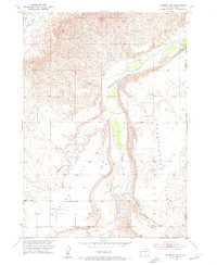
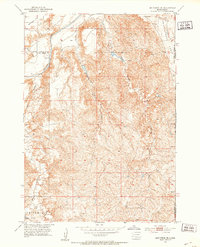
Pine Ridge Indian Reservation lands within Shannon County are defined here by a series of prominent drainage systems and high plateaus. The topography is dominated by the Squaw-Humper Table in the northwest, a distinctive landform that gives rise to Squaw-Humper Creek. The 1951 field survey reveals an area defined by natural boundaries rather than dense human settlement, illustrating the complex hydrology of the region through the branching of Middle Fork Willow Creek, East Fork Willow Creek, and West Fork Willow Creek. These watercourses carve through the terrain, indicating a landscape where seasonal water flow and livestock grazing were primary considerations. The inclusion of 1970s revisions highlights the enduring physical geography of the reservation as it stood in the mid-20th century.
Find a feature on this map
8 named features on this map. Tap any name to fly to it.
Don’t see what you’re looking for? This feature index may not catch every label — zoom into the map to look around manually.
Map Details
Editions of this 1951 Willow Creek NW Map
2 editions found
Other maps of this area

1894 · Hermosa
USGS Topo · 1:125,000

1896 · Oelrichs
USGS Topo · 1:125,000

1900 · Oelrichs
USGS Topo · 1:125,000

1901 · Hermosa
USGS Topo · 1:125,000
1951 · Fairburn SE
USGS Topo · 1:24,000
1951 · Willow Creek NW
USGS Topo · 1:24,000
1951 · Willow Creek NE
USGS Topo · 1:24,000
1951 · Red Shirt SW
USGS Topo · 1:24,000
1951 · Smithwick NE
USGS Topo · 1:24,000
1951 · Cuny Table West
USGS Topo · 1:24,000