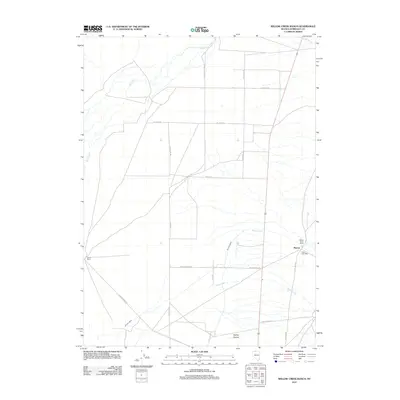
2011 Map of Willow Creek Ranch
USGS Topo · Published 2011About this map
Quinn River meanders across this northern Nevada landscape, defining the hydrology of a region where ranching and high-desert drainage patterns dictate the layout of the land. The settlement of Platora serves as a focal point in the eastern portion of the quadrangle, notably featuring the Platora Post Office as a vital link for the surrounding rural community. To the west, the Home Ranch and its namesake Willow Creek Ranch anchor the local geography, connected by a network of utilitarian thoroughfares like Old Valley Rd and Takamara Rd. This map captures a moment in the early 21st century when the traditional ranching heritage of Humboldt County remained the primary footprint on the terrain. Water sources such as Eagle Creek and Skull Creek flow through the basin, while Spring Canyon adds topographical depth to the south, illustrating the drainage systems that support this arid environment.
Find a feature on this map
19 named features on this map. Tap any name to fly to it.
Don’t see what you’re looking for? This feature index may not catch every label — zoom into the map to look around manually.
Map Details
Editions of this 2011 Willow Creek Ranch Map
This is the sole edition of this map. No revisions or reprints were ever made.
Other maps of this area

1882 · Paradise
USGS Topo · 1:250,000

1893 · Paradise
USGS Topo · 1:250,000

1955 · McDermitt
USGS Topo · 1:250,000

1959 · McDermitt
USGS Topo · 1:250,000

1959 · Orovada
USGS Topo · 1:62,500

1959 · McDermitt
USGS Topo · 1:62,500

1959 · Hinkey Summit
USGS Topo · 1:62,500

1959 · Jordan Meadow
USGS Topo · 1:62,500

1985 · Quinn River Valley
USGS Topo · 1:100,000
1991 · Hoppin Peaks
USGS Topo · 1:24,000