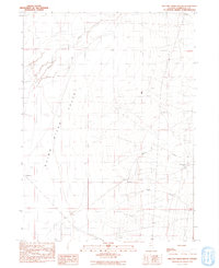
1991 Map of Willow Creek Ranch
USGS Topo · Published 1991About this map
Quinn River Valley dominates this 1991 landscape, where the Quinn River meanders through a broad basin in Nevada's high desert. This provisional survey captures the agricultural and industrial footprint of the region during the late twentieth century, anchored by the Home Ranch and Willow Creek Ranch. The map reveals a working landscape where water management and infrastructure are paramount, evidenced by the prominent Transmission Line and a dedicated Landing Strip servicing these remote outposts. Resource extraction is scattered across the terrain in the form of multiple Borrow Pit sites, a Quarry, and a Gravel Pit. Drainage from the rising terrain to the east is funneled through Willow Creek and Eagle Creek, feeding into the larger valley system and supporting the ranching operations that have long defined this corner of Humboldt County.
Find a feature on this map
14 named features on this map. Tap any name to fly to it.
Don’t see what you’re looking for? This feature index may not catch every label — zoom into the map to look around manually.
Map Details
Editions of this 1991 Willow Creek Ranch Map
This is the sole edition of this map. No revisions or reprints were ever made.
Other maps of this area

1882 · Paradise
USGS Topo · 1:250,000

1893 · Paradise
USGS Topo · 1:250,000

1955 · McDermitt
USGS Topo · 1:250,000

1959 · McDermitt
USGS Topo · 1:250,000

1959 · Orovada
USGS Topo · 1:62,500

1959 · McDermitt
USGS Topo · 1:62,500

1959 · Hinkey Summit
USGS Topo · 1:62,500

1959 · Jordan Meadow
USGS Topo · 1:62,500

1985 · Quinn River Valley
USGS Topo · 1:100,000
1991 · Hoppin Peaks
USGS Topo · 1:24,000