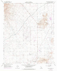
1965 Map of Willow Springs
USGS Topo · Published 1976About this map
Willow Springs sits at a historic desert crossroads where the Mojave floor meets the eastern slopes of the Tehachapi Mountains. This mid-1960s landscape, updated in the 1970s, reveals a mix of early mining industry and evolving recreational land use. Significant mining operations are visible at the Cactus Queen Mine and Gold Peak Mine near Middle Butte, complemented by a nearby Quarry Pit and numerous prospects. The vital movement of water across this arid terrain is evidenced by the massive Los Angeles Aqueduct cutting through the center and the presence of localized sources like Bean Spring. Local history and culture are further marked by the Wagon Wheel Ranch, the high-speed Willow Springs Raceway, and a lone Grave located south of the foothills, while the Horse Thief Trail hints at older paths through the high desert.
Find a feature on this map
27 named features on this map. Tap any name to fly to it.
Don’t see what you’re looking for? This feature index may not catch every label — zoom into the map to look around manually.
Map Details
Editions of this 1965 Willow Springs Map
2 editions found
Other maps of this area

1915 · Elizabeth Lake
USGS Topo · 1:125,000

1915 · Mojave
USGS Topo · 1:125,000

1917 · Elizabeth Lake
USGS Topo · 1:125,000

1943 · Rosamond
USGS Topo · 1:62,500

1943 · Tehachapi
USGS Topo · 1:62,500

1943 · Mojave
USGS Topo · 1:62,500

1943 · Willow Springs
USGS Topo · 1:62,500
1947 · Rosamond
USGS Topo · 1:24,000

1947 · Mojave
USGS Topo · 1:24,000

1947 · Soledad Mountain
USGS Topo · 1:24,000