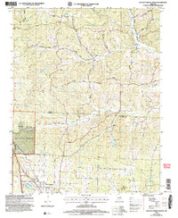
2004 Map of Willow Springs North
USGS Topo · Published 2006About this map
The Mark Twain National Forest dominates much of this landscape, where the southern Ozark terrain transitions from high ridges to deep-cut hollows along the Texas and Howell County line. Near the southern edge, the town of Willow Springs serves as a local hub, supported by water resources like the Frisco Reservoir and recreational spaces including a Golf Course. The hydrology of the area is defined by the headwaters of several notable Ozark streams, including the South Fork Jacks Fork and Pine Creek, which wind through timbered slopes. Evidence of rural infrastructure and local history is found in several scattered cemeteries and a Covered Bridge located along the banks of Elk Creek. A network of family-named corridors such as Sargent Road and Jackson Road provides access through the heavily forested sections of the quadrangle.
Find a feature on this map
30 named features on this map. Tap any name to fly to it.
Don’t see what you’re looking for? This feature index may not catch every label — zoom into the map to look around manually.
Map Details
Editions of this 2004 Willow Springs North Map
This is the sole edition of this map. No revisions or reprints were ever made.
Other maps of this area

1939 · Topaz
USGS Topo · 1:62,500

1941 · Topaz
USGS Topo · 1:62,500

1945 · Harrison
USGS Topo · 1:250,000

1945 · Willow Springs
USGS Topo · 1:62,500

1945 · Clear Springs
USGS Topo · 1:62,500

1948 · Clear Springs
USGS Topo · 1:62,500

1948 · Willow Springs
USGS Topo · 1:62,500

1949 · Harrison
USGS Topo · 1:250,000

1949 · Rolla
USGS Topo · 1:250,000

1951 · Cabool SE
USGS Topo · 1:24,000