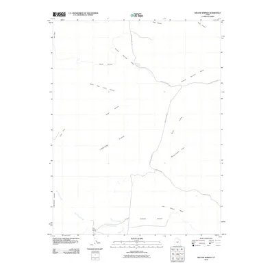
2010 Map of Willow Springs
USGS Topo · Published 2010About this map
The arid high-desert landscape of Sevier County is defined here by deep canyons and prominent escarpments, notably the Limestone Cliffs that overlook the southwest corner. The drainage system of Willow Springs Wash and Last Chance Wash cuts through the terrain, illustrating the seasonal water patterns of this part of Utah. Two remote agricultural holdings, Jims Farm and the Last Chance Ranch, provide evidence of human attempts to settle this demanding environment. Local transportation is limited to a few named routes such as the Lower Last Chance Loop and Albrecht Res Rd, which navigate between the massive Blue Flats and the Last Chance Desert. This 2010 survey highlights the contrast between the sharp relief of North Fork Indian Canyon and the broad, open expanses of Clay Flats.
Find a feature on this map
19 named features on this map. Tap any name to fly to it.
Don’t see what you’re looking for? This feature index may not catch every label — zoom into the map to look around manually.
Map Details
Editions of this 2010 Willow Springs Map
This is the sole edition of this map. No revisions or reprints were ever made.
Other maps of this area

1885 · Fish Lake
USGS Topo · 1:250,000

1896 · Fish Lake
USGS Topo · 1:250,000

1922 · Emery No.3
USGS Topo · 1:31,680

1925 · Acord Lakes
USGS Topo · 1:62,500

1956 · Salina
USGS Topo · 1:250,000

1960 · Salina
USGS Topo · 1:250,000

1962 · Salina
USGS Topo · 1:250,000

1968 · Johns Peak
USGS Topo · 1:24,000
1968 · Old Woman Plateau
USGS Topo · 1:24,000
1968 · Solomons Temple
USGS Topo · 1:24,000