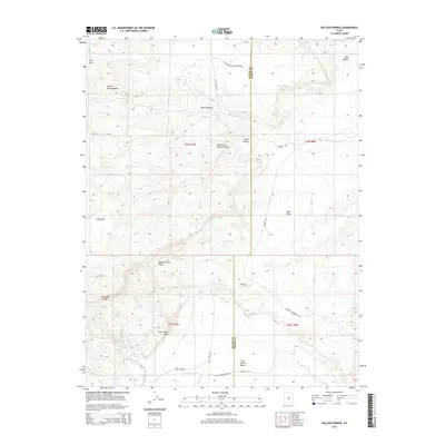
2014 Map of Willow Springs
USGS Topo · Published 2014About this map
Limestone Cliffs dominate the southwestern corner of this high-desert landscape where Sevier and Emery counties meet. The area is defined by a series of dramatic canyon systems and washes, including Indian Canyon and the winding Willow Springs Wash. Sparse human activity is concentrated at Jims Farm in the northwest, while the rest of the quadrangle reveals a rugged, arid environment characterized by expansive level areas like Clay Flats and the Blue Flats.
Find a feature on this map
28 named features on this map. Tap any name to fly to it.
Don’t see what you’re looking for? This feature index may not catch every label — zoom into the map to look around manually.
Map Details
Editions of this 2014 Willow Springs Map
This is the sole edition of this map. No revisions or reprints were ever made.
Other maps of this area

1885 · Fish Lake
USGS Topo · 1:250,000

1896 · Fish Lake
USGS Topo · 1:250,000

1922 · Emery No.3
USGS Topo · 1:31,680

1925 · Acord Lakes
USGS Topo · 1:62,500

1956 · Salina
USGS Topo · 1:250,000

1960 · Salina
USGS Topo · 1:250,000

1962 · Salina
USGS Topo · 1:250,000

1968 · Johns Peak
USGS Topo · 1:24,000
1968 · Old Woman Plateau
USGS Topo · 1:24,000
1968 · Solomons Temple
USGS Topo · 1:24,000