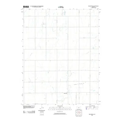
2009 Map of Willowdale
USGS Topo · Published 2009About this map
Willowdale serves as the central settlement in this portion of Kingman County, established amidst an agricultural landscape defined by a network of drainage systems. The terrain is intricately etched by several named waterways, including Mead Creek, Pat Creek, and Peters Creek, which flow through the sectioned plains. This 2009 USGS survey also documents the industrial presence of the Willowdale Oil and Gas Field in the southeastern quadrant, illustrating the intersection of Kansas's rural homesteading patterns with its energy resources. The survey utilizes a strict grid of section roads, such as SW 100 St and SW 110 Ave, which organize the farmsteads and fields that characterize this region. For the local historian, the map provides a precise layout of this small community and its surrounding natural hydrology shortly after the turn of the twenty-first century.
Find a feature on this map
21 named features on this map. Tap any name to fly to it.
Don’t see what you’re looking for? This feature index may not catch every label — zoom into the map to look around manually.
Map Details
Editions of this 2009 Willowdale Map
This is the sole edition of this map. No revisions or reprints were ever made.
Other maps of this area

1889 · Anthony
USGS Topo · 1:125,000

1891 · Anthony
USGS Topo · 1:125,000

1892 · Kingman
USGS Topo · 1:125,000

1894 · Kingman
USGS Topo · 1:125,000

1955 · Pratt
USGS Topo · 1:250,000

1959 · Pratt
USGS Topo · 1:250,000

1966 · Cunningham
USGS Topo · 1:24,000
1966 · St Leo
USGS Topo · 1:24,000

1967 · Kingman NW
USGS Topo · 1:24,000

1967 · Cleveland
USGS Topo · 1:24,000