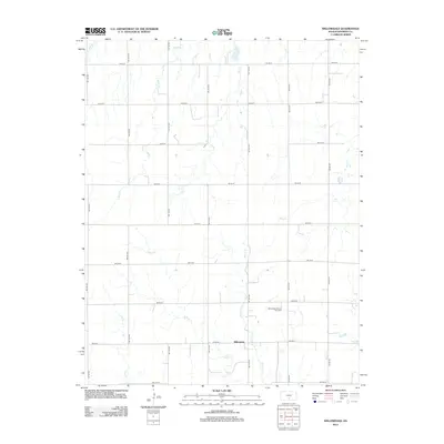
2012 Map of Willowdale
USGS Topo · Published 2012About this map
The unincorporated community of Willowdale serves as the quiet center of this agricultural landscape in Kingman County during the early 21st century. The map reveals a highly structured grid of section-line roads, such as SW 90 St and SW 100 Ave, which facilitate the region's farming and energy operations. The local economy is underscored by the Willowdale Oil and Gas Field, a prominent industrial feature situated just east of the main settlement. A network of small waterways, including Allen Cr, Peters Cr, and Mead Cr, meander through the terrain, contrasting the rigid human-imposed geometry of the road network. This survey captures the intersection of traditional Kansas prairie agriculture with modern energy extraction, providing a clear record of land use and resource management in the Great Plains.
Find a feature on this map
26 named features on this map. Tap any name to fly to it.
Don’t see what you’re looking for? This feature index may not catch every label — zoom into the map to look around manually.
Map Details
Editions of this 2012 Willowdale Map
This is the sole edition of this map. No revisions or reprints were ever made.
Other maps of this area

1889 · Anthony
USGS Topo · 1:125,000

1891 · Anthony
USGS Topo · 1:125,000

1892 · Kingman
USGS Topo · 1:125,000

1894 · Kingman
USGS Topo · 1:125,000

1955 · Pratt
USGS Topo · 1:250,000

1959 · Pratt
USGS Topo · 1:250,000

1966 · Cunningham
USGS Topo · 1:24,000
1966 · St Leo
USGS Topo · 1:24,000

1967 · Kingman NW
USGS Topo · 1:24,000

1967 · Cleveland
USGS Topo · 1:24,000