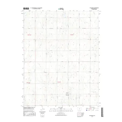
2015 Map of Willowdale
USGS Topo · Published 2015About this map
Willowdale serves as the central focal point of this Kingman County landscape, a small community positioned at the intersection of SW 90 St and SW 100 Ave. The map highlights the Saint Peter Catholic Cem, a site of significant genealogical value for the region. The surrounding terrain is defined by a dense network of intermittent prairie streams that carve through the agricultural sections. These waterways, including Mead Cr, Allen Cr, and Peters Cr, illustrate the drainage patterns typical of south-central Kansas. The strict grid of the Public Land Survey System is visible through roads like Zenda Rd and Cleveland Rd, which partition the land into regular sections for farming and ranching. This document provides a look at the rural township structure and the enduring landmarks that anchor this small community.
Find a feature on this map
35 named features on this map. Tap any name to fly to it.
Don’t see what you’re looking for? This feature index may not catch every label — zoom into the map to look around manually.
Map Details
Editions of this 2015 Willowdale Map
This is the sole edition of this map. No revisions or reprints were ever made.
Other maps of this area

1889 · Anthony
USGS Topo · 1:125,000

1891 · Anthony
USGS Topo · 1:125,000

1892 · Kingman
USGS Topo · 1:125,000

1894 · Kingman
USGS Topo · 1:125,000

1955 · Pratt
USGS Topo · 1:250,000

1959 · Pratt
USGS Topo · 1:250,000

1966 · Cunningham
USGS Topo · 1:24,000
1966 · St Leo
USGS Topo · 1:24,000

1967 · Kingman NW
USGS Topo · 1:24,000

1967 · Cleveland
USGS Topo · 1:24,000