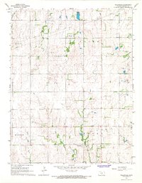
1967 Map of Willowdale
USGS Topo · Published 1968About this map
Willowdale serves as the primary focal point of this rural Kingman County landscape during the mid-1960s. The settlement is positioned near the confluence of Peters Creek and Pettyt Creek, highlighting the importance of natural drainage in this agricultural section of Kansas. The map captures an era of infrastructure development and resource extraction, evidenced by a prominent Pipeline cutting across the northern sections and an Oil Well located among the tributary headwaters of Meadow Creek. The terrain is defined by a dense network of seasonal waterways, including Painter Creek, Allen Creek, and Cross Creek, which carve through the land between the townships of Peters and Union. This survey provides a precise look at the rural road grid and land divisions before modern agricultural consolidation significantly altered the footprint of local farmsteads.
Find a feature on this map
14 named features on this map. Tap any name to fly to it.
Don’t see what you’re looking for? This feature index may not catch every label — zoom into the map to look around manually.
Map Details
Editions of this 1967 Willowdale Map
This is the sole edition of this map. No revisions or reprints were ever made.
Other maps of this area

1889 · Anthony
USGS Topo · 1:125,000

1891 · Anthony
USGS Topo · 1:125,000

1892 · Kingman
USGS Topo · 1:125,000

1894 · Kingman
USGS Topo · 1:125,000

1955 · Pratt
USGS Topo · 1:250,000

1959 · Pratt
USGS Topo · 1:250,000

1966 · Cunningham
USGS Topo · 1:24,000
1966 · St Leo
USGS Topo · 1:24,000

1967 · Kingman NW
USGS Topo · 1:24,000

1967 · Cleveland
USGS Topo · 1:24,000