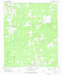
1973 Map of Wilmar North
USGS Topo · Published 1975About this map
The Saline River winds through the southwestern corner of this landscape, marking a low-lying riparian corridor where Franklin Creek and Langford Creek converge. In the early 1970s, this portion of Drew and Bradley Counties was defined by a mix of timberland and small rural communities connected by the Missouri Pacific railroad. The town of Wilmar serves as a primary hub in the south, while smaller settlements like Barkada and Rye are anchored by local landmarks such as Bethel Cemetery and Torian Cemetery.
Find a feature on this map
31 named features on this map. Tap any name to fly to it.
Don’t see what you’re looking for? This feature index may not catch every label — zoom into the map to look around manually.
Map Details
Editions of this 1973 Wilmar North Map
This is the sole edition of this map. No revisions or reprints were ever made.
Other maps of this area

1935 · Feenyville
USGS Topo · 1:62,500

1953 · Greenwood
USGS Topo · 1:250,000

1953 · El Dorado
USGS Topo · 1:250,000

1956 · Greenwood
USGS Topo · 1:250,000

1957 · El Dorado
USGS Topo · 1:250,000

1958 · El Dorado
USGS Topo · 1:250,000

1960 · El Dorado
USGS Topo · 1:250,000

1966 · Monticello North
USGS Topo · 1:24,000
1966 · Monticello South
USGS Topo · 1:24,000

1970 · Herbine
USGS Topo · 1:24,000