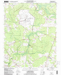
1997 Map of Wilmar
USGS Topo · Published 2000About this map
VOICE OF AMERICA (Site B) dominates the northern landscape of this coastal plain region, a massive broadcasting facility marked by numerous Radio Towers. This Cold War-era infrastructure stands in stark contrast to the surrounding rural character of the land, which is defined by an intricate network of wetlands including Clayroot Swamp, Creeping Swamp, and Thorofare Swamp. The map documents the intersections of Pitt, Beaufort, and Craven counties, where small settlements like Elmira Crossroads and Wilmar serve as local anchors.
Find a feature on this map
26 named features on this map. Tap any name to fly to it.
Don’t see what you’re looking for? This feature index may not catch every label — zoom into the map to look around manually.
Map Details
Editions of this 1997 Wilmar Map
This is the sole edition of this map. No revisions or reprints were ever made.
Other maps of this area

1902 · Ayden
USGS Topo · 1:62,500

1902 · Vanceboro
USGS Topo · 1:62,500

1903 · Winterville
USGS Topo · 1:62,500

1903 · Chocowinity
USGS Topo · 1:62,500

1904 · Ayden
USGS Topo · 1:62,500

1904 · Vanceboro
USGS Topo · 1:62,500

1905 · Chocowinity
USGS Topo · 1:62,500

1905 · Winterville
USGS Topo · 1:62,500

1905 · Vanceboro
USGS Topo · 1:62,500

1951 · Hackney
USGS Topo · 1:24,000