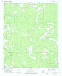
1972 Map of Wilmar South
USGS Topo · Published 1975About this map
The Saline River and its complex network of sloughs and creeks dominate this pocket of Southeast Arkansas, where the Bradley Co Drew Co line follows the meandering watercourse. In the early 1970s, the rural landscape was defined by small settlements like Wilmar, Green Hill, and New Hope, many situated along the rail corridor of the Missouri Pacific or near the high ground of the creek divides. The area is dense with community landmarks that provide significant value for family historians, including numerous burial grounds such as Turner Hills Cem, Corinth-O'Neil Cem, and Old Saline Cem. Cultural life is further anchored by local congregations at Shiloh Ch and New Hope Ch. The terrain transitions from the low, wet bottoms of Gin House Slough to the upland drainage of Tenmile Creek, reflecting a traditional Southern landscape of river-bottom timber and scattered agricultural clearings.
Find a feature on this map
28 named features on this map. Tap any name to fly to it.
Don’t see what you’re looking for? This feature index may not catch every label — zoom into the map to look around manually.
Map Details
Editions of this 1972 Wilmar South Map
This is the sole edition of this map. No revisions or reprints were ever made.
Other maps of this area

1934 · Ingalls
USGS Topo · 1:48,000

1937 · Ingalls
USGS Topo · 1:62,500

1939 · Ingalls
USGS Topo · 1:62,500

1953 · Greenwood
USGS Topo · 1:250,000

1953 · El Dorado
USGS Topo · 1:250,000

1956 · Greenwood
USGS Topo · 1:250,000

1957 · El Dorado
USGS Topo · 1:250,000

1958 · El Dorado
USGS Topo · 1:250,000

1960 · El Dorado
USGS Topo · 1:250,000

1966 · Monticello North
USGS Topo · 1:24,000