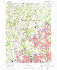
1967 Map of Wilmington North
USGS Topo · Published 1975About this map
The Brandywine Creek valley serves as the central artery for this survey, illustrating a landscape defined by industrial history and the preservation of large country estates. Near the southern edge, the Hagley Museum and Brandywine Park mark the transition into the urban core of Wilmington, while further north, the map documents the expansive grounds of Winterthur and the Brandywine Creek State Park. The terrain is characterized by the winding creek and its tributaries, including Husbands Run and Rocky Run, which carved the valleys that supported early milling operations and later suburban development.
Find a feature on this map
118 named features on this map. Tap any name to fly to it.
Don’t see what you’re looking for? This feature index may not catch every label — zoom into the map to look around manually.
Map Details
Editions of this 1967 Wilmington North Map
4 editions found
Other maps of this area

1890 · Salem
USGS Topo · 1:62,500

1894 · Chester
USGS Topo · 1:62,500

1896 · Chester
USGS Topo · 1:62,500

1898 · Salem
USGS Topo · 1:62,500

1898 · Chester
USGS Topo · 1:62,500

1901 · Camden
USGS Topo · 1:125,000

1901 · West Chester
USGS Topo · 1:62,500

1904 · West Chester
USGS Topo · 1:62,500

1904 · Wilmington
USGS Topo · 1:62,500

1906 · Wilmington
USGS Topo · 1:62,500