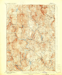
1889 Map of Wilmington
USGS Topo · Published 1931About this map
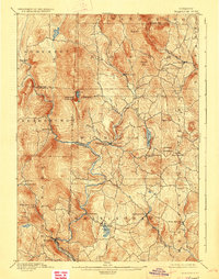
The Deerfield River carves a deep path through Windham County in this late 19th-century survey, anchoring a landscape of steep peaks and high-elevation ponds. The Hoosac Tunnel and Wilmington R.R. follows the river's tight curves in the south, connecting the industrial hub of Readsboro with the central settlement of Wilmington. This rail corridor was essential for the timber and emerging hydropower interests of the region, long before the massive reservoirs of the mid-20th century transformed the valley floor. High above the river, prominent landmarks like Haystack Mountain and Hogback Mountain define the horizon, while smaller villages like West Dover and Jacksonville sit nestled along tributaries like Cold Brook and the North River. Genealogists will find interest in the precise locations of rural outposts such as Davis Bridge and Readsboro Falls, which were active during this era of upland farming and mill operations.
Find a feature on this map
49 named features on this map. Tap any name to fly to it.
Don’t see what you’re looking for? This feature index may not catch every label — zoom into the map to look around manually.
Map Details
Editions of this 1889 Wilmington Map
7 editions found
Other maps of this area

1886 · Greylock
USGS Topo · 1:62,500

1886 · Hawley
USGS Topo · 1:62,500

1889 · Wilmington
USGS Topo · 1:62,500

1890 · Hawley
USGS Topo · 1:62,500

1890 · Greenfield
USGS Topo · 1:62,500

1891 · Wilmington
USGS Topo · 1:62,500

1891 · Greylock
USGS Topo · 1:62,500

1891 · Brattleboro
USGS Topo · 1:62,500

1893 · Brattleboro
USGS Topo · 1:62,500

1893 · Greylock
USGS Topo · 1:62,500