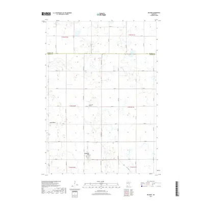
2019 Map of Wilmont
USGS Topo · Published 2019About this map
Wilmont and the smaller settlement of Saint Kilian anchor this corner of the Minnesota prairie, where the local economy is tied to a grid of rural roads and the land's natural drainage. The landscape is defined by the Coteau des Prairies, a high plateau that creates a distinct rolling terrain compared to the flatter regions nearby. Waterways like Willow Lake and Jack Cr cut through the sections, providing essential drainage for the surrounding farmland. Transportation is facilitated by a network of county roads and State Hwy 266, which connects Wilmont to the wider region. For those researching local heritage, the Calvary Cem stands on the eastern edge of Wilmont, serving as a landmark for the community's established history in this agricultural heartland.
Find a feature on this map
31 named features on this map. Tap any name to fly to it.
Don’t see what you’re looking for? This feature index may not catch every label — zoom into the map to look around manually.
Map Details
Editions of this 2019 Wilmont Map
This is the sole edition of this map. No revisions or reprints were ever made.
Other maps of this area

1954 · Fairmont
USGS Topo · 1:250,000

1958 · Fairmont
USGS Topo · 1:250,000

1960 · Reading
USGS Topo · 1:24,000

1967 · Slayton SW
USGS Topo · 1:24,000

1967 · Slayton
USGS Topo · 1:24,000

1967 · Wilmont
USGS Topo · 1:24,000

1967 · Adrian NE
USGS Topo · 1:24,000

1967 · Adrian
USGS Topo · 1:24,000
1967 · Chandler
USGS Topo · 1:24,000
1970 · Fulda SW
USGS Topo · 1:24,000