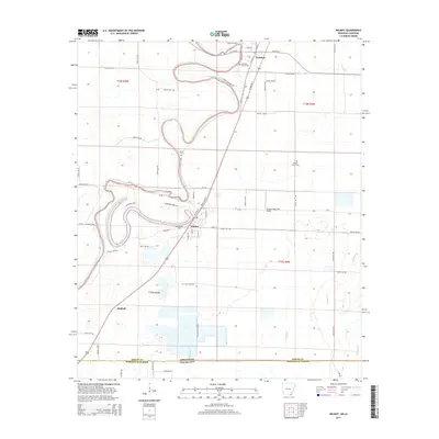
2014 Map of Wilmot
USGS Topo · Published 2014About this map
Wilmot and Parkdale anchor this landscape along the Arkansas-Louisiana border, where the winding course of Bayou Bartholomew snakes through the fertile alluvial plains of Ashley County. The map captures a transition in land use, showing the traditional grid of rural roads such as Ashley 352 Rd alongside modern infrastructure like US Hwy 165 and the Johnson Memorial Airport. To the south, the oxbow of Lake Enterprise and the presence of specialized agriculture, notably the M L Fish Farm Rd, highlight the region's historical reliance on its complex water systems. Local genealogy and settlement history are well-preserved through numerous burial sites, including Smith Cem, Wonner Grove Cem, and the Wilmot Cem, providing a detailed look at the community's footprint as it reaches the Arkansas Louisiana state line.
Find a feature on this map
67 named features on this map. Tap any name to fly to it.
Don’t see what you’re looking for? This feature index may not catch every label — zoom into the map to look around manually.
Map Details
Editions of this 2014 Wilmot Map
This is the sole edition of this map. No revisions or reprints were ever made.
Other maps of this area

1935 · Wilmot
USGS Topo · 1:62,500

1935 · Oak Grove
USGS Topo · 1:62,500

1935 · Bonita
USGS Topo · 1:62,500

1936 · Eudora
USGS Topo · 1:62,500

1953 · Greenwood
USGS Topo · 1:250,000

1955 · Jackson
USGS Topo · 1:250,000

1956 · Greenwood
USGS Topo · 1:250,000

1957 · Eudora
USGS Topo · 1:62,500

1958 · Oak Grove
USGS Topo · 1:62,500

1958 · Bonita
USGS Topo · 1:62,500