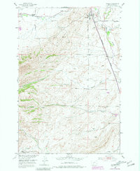
1951 Map of Wilsall
USGS Topo · Published 1981About this map
Wilsall serves as the focal point of this Park County landscape, situated where the Burlington Northern railroad corridor meets the winding path of the Shields River. The settlement pattern reflects the agricultural and educational needs of the mid-20th century, evidenced by landmarks like the Wilsall Cemetery and the BM Meyersburg Sch in nearby Meyersburg. To the south, the Brackett Creek School highlights how rural education was distributed across the valley near the base of the prominent Battle Ridge.
Find a feature on this map
18 named features on this map. Tap any name to fly to it.
Don’t see what you’re looking for? This feature index may not catch every label — zoom into the map to look around manually.
Map Details
Editions of this 1951 Wilsall Map
3 editions found
Other maps of this area

1886 · Little Belt Mts.
USGS Topo · 1:250,000

1891 · Livingston
USGS Topo · 1:250,000

1893 · Livingston
USGS Topo · 1:250,000

1894 · Little Belt Mts.
USGS Topo · 1:250,000

1897 · Little Belt Mts.
USGS Topo · 1:250,000

1898 · Little Belt Mts.
USGS Topo · 1:250,000

1902 · Little Belt Mts.
USGS Topo · 1:250,000

1947 · Bozeman
USGS Topo · 1:250,000

1948 · Bozeman
USGS Topo · 1:250,000

1948 · White Sulphur Springs
USGS Topo · 1:250,000