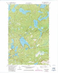
1981 Map of Wilson Lake
USGS Topo · Published 1985About this map
The Superior National Forest dominates this northeastern Minnesota landscape, revealing a dense network of glacial lakes and waterways just before the mid-1980s. Large bodies of water like Wilson Lake, Silver Island Lake, and Windy Lake are interconnected by numerous creeks and portages, including Windy Cr and Benoit Creek. The map provides significant industrial context through the presence of a Railroad Grade and an Old Grade in the southern portion of the quadrangle, indicating the region's history with timber extraction or early transport. These terrestrial marks contrast with the largely untouched aquatic environments of Whitefish Lake, Elbow Lake, and the winding course of the Cross River. Sparse human infrastructure is limited to occasional Public Access points and scattered Gravel Pit locations, reflecting a transition toward managed conservation and recreation within the forest boundaries.
Find a feature on this map
45 named features on this map. Tap any name to fly to it.
Don’t see what you’re looking for? This feature index may not catch every label — zoom into the map to look around manually.
Map Details
Editions of this 1981 Wilson Lake Map
2 editions found
Other maps of this area

1954 · Two Harbors
USGS Topo · 1:250,000

1955 · Schroeder
USGS Topo · 1:24,000

1955 · Tofte
USGS Topo · 1:62,500

1955 · Cramer
USGS Topo · 1:62,500

1957 · Two Harbors
USGS Topo · 1:250,000

1958 · Two Harbors
USGS Topo · 1:250,000

1960 · Kawishiwi Lake
USGS Topo · 1:24,000

1960 · Perent Lake
USGS Topo · 1:24,000

1960 · Beth Lake
USGS Topo · 1:24,000

1964 · Two Harbors
USGS Topo · 1:250,000