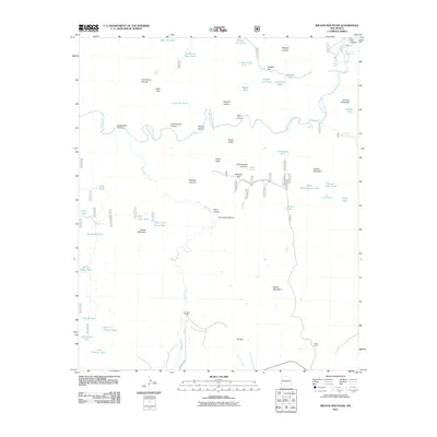
2011 Map of Wilson Mountain
USGS Topo · Published 2011About this map
San Francisco Hot Springs and Frisco Hot Springs sit along the winding San Francisco River in this western New Mexico landscape. The terrain is defined by dramatic elevation changes, from the heights of Wilson Mountain and Hanna Mountain to the depths of Squirrel Canyon and Lost Grave Canyon. The map reveals a land managed for cattle and water, dotted with numerous stock tanks such as Lollipop Tank, Cat Claw Tank, and Brandy Tree Tank. Local ranching history is anchored by the Zumwalt Ranch and Henry Ranch, located in the southern reaches near Goats Pass RD. The distinctive topography includes geological landmarks like the Potholes Country, Angel Roost, and the sheer walls of The Box, where the Pine Cienega Creek cuts through the high desert floor.
Find a feature on this map
62 named features on this map. Tap any name to fly to it.
Don’t see what you’re looking for? This feature index may not catch every label — zoom into the map to look around manually.
Map Details
Editions of this 2011 Wilson Mountain Map
This is the sole edition of this map. No revisions or reprints were ever made.
Other maps of this area

1910 · Mogollon
USGS Topo · 1:125,000

1912 · Mogollon
USGS Topo · 1:125,000

1913 · Morenci
USGS Topo · 1:125,000

1915 · Morenci
USGS Topo · 1:125,000

1954 · Clifton
USGS Topo · 1:250,000

1957 · Clifton
USGS Topo · 1:250,000

1958 · Clifton
USGS Topo · 1:250,000

1962 · Clifton
USGS Topo · 1:250,000

1962 · Big Lue Mts
USGS Topo · 1:62,500
1965 · Mule Creek
USGS Topo · 1:24,000