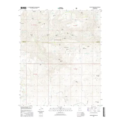
2017 Map of Wilson Mountain
USGS Topo · Published 2017About this map
The Gila National Forest landscape across the border of Catron and Grant counties is defined by the winding course of the San Francisco River. This high-elevation terrain is punctuated by significant volcanic and geothermal features, most notably the San Francisco Hot Springs and Frisco Hot Springs situated along the river banks. The map reveals an intricate network of drainage systems and summits, including Wilson Mountain, Snow Peak, and the prominent Sierra Aguilada range. Human impact in this wilderness is evidenced by numerous water management features like Lightning Mesa Tank and Brandy Tree Tank, alongside the presence of Forest RD 700b. Locations such as Lost Grave Canyon and Angel Roost hint at the local lore and isolated nature of the Mogollon Mountains region. The density of named springs, such as Branding Tree Spring and Gorilla Spring, underscores the critical importance of water sources in this high-desert environment.
Find a feature on this map
79 named features on this map. Tap any name to fly to it.
Don’t see what you’re looking for? This feature index may not catch every label — zoom into the map to look around manually.
Map Details
Editions of this 2017 Wilson Mountain Map
This is the sole edition of this map. No revisions or reprints were ever made.
Other maps of this area

1910 · Mogollon
USGS Topo · 1:125,000

1912 · Mogollon
USGS Topo · 1:125,000

1913 · Morenci
USGS Topo · 1:125,000

1915 · Morenci
USGS Topo · 1:125,000

1954 · Clifton
USGS Topo · 1:250,000

1957 · Clifton
USGS Topo · 1:250,000

1958 · Clifton
USGS Topo · 1:250,000

1962 · Clifton
USGS Topo · 1:250,000

1962 · Big Lue Mts
USGS Topo · 1:62,500
1965 · Mule Creek
USGS Topo · 1:24,000