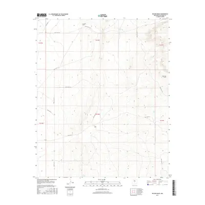
2017 Map of Wilson Ranch
USGS Topo · Published 2017About this map
Wilson Ranch sits at the heart of this high-desert landscape in Socorro County, a region defined by its wide basins and isolated water sources. This 2017 survey shows a geography primarily structured for grazing and transit within the White Sands Missile Range (WSMR) boundaries, evidenced by the network of numbered routes like WSMR P Route 9 and WSMR P Route 18. Vital water catchments such as Sandy Tank, Lake Tank, and O'Neal Tank are scattered across the terrain, highlighting the essential infrastructure required for survival in this arid environment. The map also delineates natural drainages including Grumble Gulch and Mesa Well Canyon, which carve through the high elevations of the surrounding mesas. The intersection of these natural landforms with modern administrative road systems reflects the dual-use history of these remote lands for both agricultural ranching and government operations.
Find a feature on this map
18 named features on this map. Tap any name to fly to it.
Don’t see what you’re looking for? This feature index may not catch every label — zoom into the map to look around manually.
Map Details
Editions of this 2017 Wilson Ranch Map
This is the sole edition of this map. No revisions or reprints were ever made.
Other maps of this area

1918 · Oscura Peak
USGS Topo · 1:125,000

1948 · Broken Back Crater
USGS Topo · 1:62,500

1948 · Bingham
USGS Topo · 1:62,500

1954 · Tularosa
USGS Topo · 1:250,000

1954 · Socorro
USGS Topo · 1:250,000

1958 · Socorro
USGS Topo · 1:250,000

1958 · Tularosa
USGS Topo · 1:250,000

1962 · Socorro
USGS Topo · 1:250,000

1972 · Turkey Ridge
USGS Topo · 1:24,000

1972 · Turkey Ridge SW
USGS Topo · 1:24,000