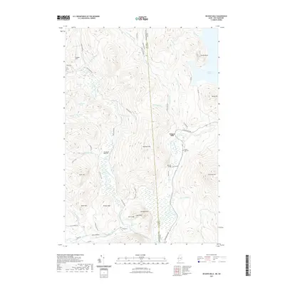
2021 Map of Wilsons Mills
USGS Topo · Published 2021About this map
Wilsons Mills occupies a narrow shelf above the Magalloway River as it winds through the Oxford County highlands, marking a vital point of transit along the Wilsons Mills Rd corridor. The river network dominates this landscape, where the Dead Diamond River and Swift Diamond River merge and flow south through a complex wetland valley. This 2021 survey illustrates the intersection of water and land use, from the managed waters of Aziscohos Lake in the east to the remote logging roads like Parmachenee Rd and Dead Diamond Rd that snake through the peaks. Local history and topography are woven together in labels such as Lincoln Plantation Cem and the nearby Bennett Bridge, while distinctive landmarks like Finnsons Cliff, Monahans Bathtub, and Emerys Misery suggest a terrain deeply tied to the stories of early surveyors and woodsmen.
Find a feature on this map
56 named features on this map. Tap any name to fly to it.
Don’t see what you’re looking for? This feature index may not catch every label — zoom into the map to look around manually.
Map Details
Editions of this 2021 Wilsons Mills Map
This is the sole edition of this map. No revisions or reprints were ever made.
Other maps of this area

1927 · Second Lake
USGS Topo · 1:62,500

1930 · Errol
USGS Topo · 1:62,500

1931 · Cupsuptic
USGS Topo · 1:48,000

1932 · Second Lake
USGS Topo · 1:62,500

1934 · Cupsuptic
USGS Topo · 1:62,500

1934 · Errol
USGS Topo · 1:62,500

1935 · Cupsuptic
USGS Topo · 1:62,500

1940 · Oquossoc
USGS Topo · 1:62,500

1942 · Oquossoc
USGS Topo · 1:62,500

1949 · Jackman
USGS Topo · 1:250,000
Featured Places
- Magalloway Plantation, ME
- Lincoln Plantation, ME
- Wilsons Mills, Lincoln Plantation
- Atkinson and Gilmanton Academy Grant, NH
- Second College Grant, NH