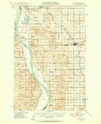
1950 Map of Wilton
USGS Topo · Published 1950About this map
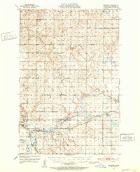
Square Buttes rise prominently above the eastern banks of the Missouri River in this mid-century survey of the North Dakota landscape. The map captures a moment when the rural district was heavily subdivided into numbered school sections, featuring local landmarks like Nettle Creek Sch No 1 and Price Sch No 11. The town of Wilton serves as the primary hub, where the Northern Pacific and Minneapolis St Paul and Sault Ste Marie rail lines intersect, supporting local commerce including an Inactive Mine. Cultural history is preserved at the Molander Indian Village Historic Site near the river, while the natural environment is managed through the Lost Lake and Yanktonai National Wildlife Refuges. The map also documents several small rural settlements like Merida, Sanger, and Wogansport, alongside several country cemeteries such as Riverview Cem and Wing Cem.
Find a feature on this map
37 named features on this map. Tap any name to fly to it.
Don’t see what you’re looking for? This feature index may not catch every label — zoom into the map to look around manually.
Map Details
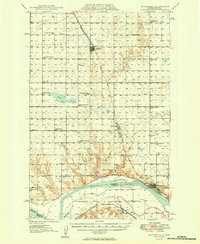
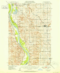
Editions of this 1950 Wilton Map
2 editions found
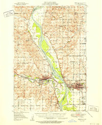
Other maps of this area

1907 · Bismarck
USGS Topo · 1:125,000

1949 · Turtle Creek
USGS Topo · 1:62,500
1949 · Washburn
USGS Topo · 1:62,500
1950 · Wilton
USGS Topo · 1:62,500
1951 · Bismarck
USGS Topo · 1:62,500
1951 · Menoken
USGS Topo · 1:62,500

1954 · Bismarck
USGS Topo · 1:250,000

1954 · McClusky
USGS Topo · 1:250,000

1958 · Bismarck
USGS Topo · 1:250,000

1958 · McClusky
USGS Topo · 1:250,000