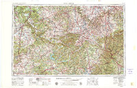
1957 Map of Winchester
USGS Topo · Published 1980About this map
Lexington and the surrounding Bluegrass region serve as the central hub for this mid-century survey of central Kentucky. The landscape is defined by the winding course of the Kentucky River and its tributaries, which carved through the limestone plateau to create features like the Knobs and Muldraugh Hill. Transportation networks are dominated by the Louisville & Nashville RR and the Southern Railway, alongside the development of major thoroughfares like the Blue Grass Parkway and Cumberland Parkway.
Find a feature on this map
133 named features on this map. Tap any name to fly to it.
Don’t see what you’re looking for? This feature index may not catch every label — zoom into the map to look around manually.
Map Details
Editions of this 1957 Winchester Map
3 editions found

Other maps of this area

1886 · Cumberland Gap
USGS Topo · 1:125,000

1888 · Cumberland Gap
USGS Topo · 1:125,000

1890 · Williamsburg
USGS Topo · 1:125,000

1891 · Manchester
USGS Topo · 1:125,000

1891 · Cumberland Gap
USGS Topo · 1:125,000

1892 · Richmond
USGS Topo · 1:125,000

1892 · Beattyville
USGS Topo · 1:125,000

1893 · London
USGS Topo · 1:125,000

1894 · Williamsburg
USGS Topo · 1:125,000

1897 · Richmond
USGS Topo · 1:125,000