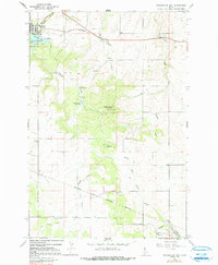
1967 Map of Winchester East
USGS Topo · Published 1981About this map
Winchester sits at the northern edge of this high prairie landscape on the Nez Perce Indian Reservation Boundary. The map illustrates a transition from the lakeside recreation at Winchester State Park and Lapwai Lake to the agricultural reaches of Lewis County. An Old Railroad Grade snakes across the northern sections, tracing the historic path of transit through the canyons. Further south, the settlement of Morrow and the nearby Morrow Cem provide touchpoints for local genealogy. The terrain is defined by deep drainages like Big Canyon Creek and North Fork Willow Creek, while local education and gathering spots are represented by the Pine Grove School and Talmaks Campground. This 1967 survey preserves the distribution of homesteads and small-scale infrastructure before late-century shifts.
Find a feature on this map
24 named features on this map. Tap any name to fly to it.
Don’t see what you’re looking for? This feature index may not catch every label — zoom into the map to look around manually.
Map Details
Editions of this 1967 Winchester East Map
2 editions found
Other maps of this area

1924 · Kamiah
USGS Topo · 1:125,000

1955 · Pullman
USGS Topo · 1:250,000

1958 · Pullman
USGS Topo · 1:250,000

1958 · Culdesac
USGS Topo · 1:62,500

1967 · Fletcher
USGS Topo · 1:24,000

1967 · Craigmont
USGS Topo · 1:24,000

1967 · Hoover Point
USGS Topo · 1:24,000

1967 · Westlake
USGS Topo · 1:24,000
1967 · Keuterville
USGS Topo · 1:24,000
1967 · Winchester East
USGS Topo · 1:24,000