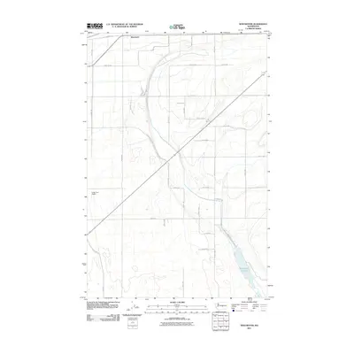
2011 Map of Winchester
USGS Topo · Published 2011About this map
Winchester sits at the heart of this agricultural landscape in Grant County, defined by a meticulously planned grid of irrigation and transport. The local economy and infrastructure are shaped by the Winchester Wasteway and several canals, including the path alongside Canel Rd, which facilitate the region's intensive farming operations. This 2011 survey reveals how the arid terrain has been transformed into productive acreage, supported by specialized facilities like the Grigg Farm Airport. The extensive network of named roads, such as Winchester Rd NW and Road 10 NW, reflects the organized settlement pattern typical of the Columbia Basin Project area, where water management and accessibility are paramount to the community's layout.
Find a feature on this map
31 named features on this map. Tap any name to fly to it.
Don’t see what you’re looking for? This feature index may not catch every label — zoom into the map to look around manually.
Map Details
Editions of this 2011 Winchester Map
This is the sole edition of this map. No revisions or reprints were ever made.
Other maps of this area

1909 · Quincy
USGS Topo · 1:62,500

1910 · Quincy
USGS Topo · 1:62,500

1910 · Winchester
USGS Topo · 1:62,500

1953 · Ritzville
USGS Topo · 1:250,000

1956 · Ephrata
USGS Topo · 1:62,500

1956 · Ephrata
USGS Topo · 1:24,000

1956 · Ephrata SW
USGS Topo · 1:24,000
1956 · Winchester SE
USGS Topo · 1:24,000

1956 · Winchester NE
USGS Topo · 1:24,000

1959 · Ritzville
USGS Topo · 1:250,000