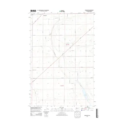
2014 Map of Winchester
USGS Topo · Published 2014About this map
Winchester sits in the northern reaches of this Central Washington landscape, where the agricultural grid of Grant County is defined by an extensive network of irrigation and maintenance routes. The drainage patterns of the Columbia Basin Project are evident in the Winchester Wasteway, which carries water southward through the arid terrain. The intersection of Wa-28 and Wa-283 provides the primary transportation spine for the region, linking the small settlement to larger agricultural hubs. Local aviation history is grounded at the Grigg Farm Airport, a characteristic private airstrip serving the industrial farming operations of the area. The map illustrates a strictly organized landscape of sections and ranges, from t20n r25e to t19n r25e, crisscrossed by roads like Winchester Rd NW and the Canal Maintenance Rd that support the local water-management economy.
Find a feature on this map
33 named features on this map. Tap any name to fly to it.
Don’t see what you’re looking for? This feature index may not catch every label — zoom into the map to look around manually.
Map Details
Editions of this 2014 Winchester Map
This is the sole edition of this map. No revisions or reprints were ever made.
Other maps of this area

1909 · Quincy
USGS Topo · 1:62,500

1910 · Quincy
USGS Topo · 1:62,500

1910 · Winchester
USGS Topo · 1:62,500

1953 · Ritzville
USGS Topo · 1:250,000

1956 · Ephrata
USGS Topo · 1:62,500

1956 · Ephrata
USGS Topo · 1:24,000

1956 · Ephrata SW
USGS Topo · 1:24,000
1956 · Winchester SE
USGS Topo · 1:24,000

1956 · Winchester NE
USGS Topo · 1:24,000

1959 · Ritzville
USGS Topo · 1:250,000