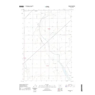
2020 Map of Winchester
USGS Topo · Published 2020About this map
Winchester sits at the northern edge of this high-desert landscape in Grant County, defined by the organized grid of the Public Land Survey System and a sophisticated network of irrigation management. The terrain is marked by the presence of the Winchester Wasteway, which meanders southward through the central township, and the Frenchman Hills Wasteway to the southwest. These channels are critical components of the region's agricultural infrastructure, managing water runoff across a series of numbered section roads ranging from Rd 11.1 Nw down to Rd 3 Nw. The intersection of drainage and transport is further evidenced by Ditch Rd, highlighting how the natural topography has been systematically engineered for irrigation and accessibility. For researchers, the map provides a clear picture of contemporary land divisions and the hydrological features that sustain the local landscape.
Find a feature on this map
33 named features on this map. Tap any name to fly to it.
Don’t see what you’re looking for? This feature index may not catch every label — zoom into the map to look around manually.
Map Details
Editions of this 2020 Winchester Map
This is the sole edition of this map. No revisions or reprints were ever made.
Other maps of this area

1909 · Quincy
USGS Topo · 1:62,500

1910 · Quincy
USGS Topo · 1:62,500

1910 · Winchester
USGS Topo · 1:62,500

1953 · Ritzville
USGS Topo · 1:250,000

1956 · Ephrata
USGS Topo · 1:62,500

1956 · Ephrata
USGS Topo · 1:24,000

1956 · Ephrata SW
USGS Topo · 1:24,000
1956 · Winchester SE
USGS Topo · 1:24,000

1956 · Winchester NE
USGS Topo · 1:24,000

1959 · Ritzville
USGS Topo · 1:250,000