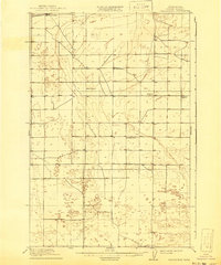
1910 Map of Winchester
USGS Topo · Published 1941About this map
The settlement of Winchester stands at the intersection of early twentieth-century logistics and rural education in this section of Grant County. Surveyed in 1909, the landscape is defined by its wide, open flats and the strategic presence of the Great Northern R R, which cuts through the northwestern corner of the quadrangle. The distribution of small country schools across the territory reveals the scattered but organized nature of the early homesteading era, with institutions like the Sunny Slope School, Mt Olive School, and Dishaw School serving as the primary civic nodes for distant farmsteads. Further south, the map identifies McEwen School and the community surrounding Morrison, including the Morrison School. The lack of dense urbanization at this time highlights a period when the region's development was tied almost exclusively to the railroad and the needs of a fledgling agricultural population.
Find a feature on this map
8 named features on this map. Tap any name to fly to it.
Don’t see what you’re looking for? This feature index may not catch every label — zoom into the map to look around manually.
Map Details
Editions of this 1910 Winchester Map
3 editions found
Other maps of this area

1909 · Quincy
USGS Topo · 1:62,500

1910 · Quincy
USGS Topo · 1:62,500

1910 · Winchester
USGS Topo · 1:62,500

1911 · Red Rock
USGS Topo · 1:62,500

1912 · Moses Lake
USGS Topo · 1:62,500

1912 · Beverly
USGS Topo · 1:62,500

1923 · Corfu
USGS Topo · 1:62,500

1950 · Smyrna
USGS Topo · 1:62,500

1951 · Smyrna
USGS Topo · 1:62,500

1951 · Corfu
USGS Topo · 1:62,500