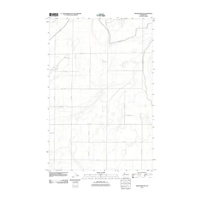
2011 Map of Winchester NE
USGS Topo · Published 2011About this map
Canal W-20 snakes through the high desert of Grant County, anchoring a landscape defined by industrial-scale agriculture and a precise grid of rural transit. In this portion of central Washington, the terrain is partitioned by an extensive network of numeric and alphabetic corridors, including Road 8.8 NW and Road 7 NW, which facilitate the movement of goods and equipment across the arid flats. The map illustrates the sophisticated irrigation infrastructure necessary for the region's productivity, with Dodson Rd N serving as a primary north-south artery. Small elevation changes are marked by contour lines that reveal the subtle drainage patterns feeding into the canal system, providing a clear view of how water management has fundamentally reshaped this section of the Columbia Basin.
Find a feature on this map
21 named features on this map. Tap any name to fly to it.
Don’t see what you’re looking for? This feature index may not catch every label — zoom into the map to look around manually.
Map Details
Editions of this 2011 Winchester NE Map
This is the sole edition of this map. No revisions or reprints were ever made.
Other maps of this area

1910 · Winchester
USGS Topo · 1:62,500

1912 · Moses Lake
USGS Topo · 1:62,500

1953 · Ritzville
USGS Topo · 1:250,000

1956 · Ephrata
USGS Topo · 1:62,500

1956 · Ephrata
USGS Topo · 1:24,000

1956 · Ephrata SW
USGS Topo · 1:24,000

1956 · Grant Orchards
USGS Topo · 1:24,000

1956 · Mae
USGS Topo · 1:24,000
1956 · Winchester SE
USGS Topo · 1:24,000

1956 · Winchester NE
USGS Topo · 1:24,000