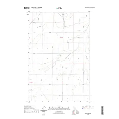
2020 Map of Winchester NE
USGS Topo · Published 2020About this map
The Pot Hole anchors the northern reaches of this central Washington landscape, where the geometry of the Columbia Basin Project's irrigation network is clearly defined. The terrain is marked by a precise grid of county roads, including Dodson Rd N and Kriete Rd, which facilitate the region's agricultural industry. The movement of water is central to this environment, managed through features like Canal W 20 and the aptly named Canal Rd. These man-made watercourses dictate the layout of the fields and farmsteads throughout Grant County. This modern survey illustrates how a high-desert environment has been methodically transformed into a productive agricultural zone through extensive engineering and infrastructure. The map provides a detailed view of the modern rural infrastructure, showing how individual road segments such as Rd 10.4 NW and Rd 9.6 NW connect remote parcels within the township and range system.
Find a feature on this map
28 named features on this map. Tap any name to fly to it.
Don’t see what you’re looking for? This feature index may not catch every label — zoom into the map to look around manually.
Map Details
Editions of this 2020 Winchester NE Map
This is the sole edition of this map. No revisions or reprints were ever made.
Other maps of this area

1910 · Winchester
USGS Topo · 1:62,500

1912 · Moses Lake
USGS Topo · 1:62,500

1953 · Ritzville
USGS Topo · 1:250,000

1956 · Ephrata
USGS Topo · 1:62,500

1956 · Ephrata
USGS Topo · 1:24,000

1956 · Ephrata SW
USGS Topo · 1:24,000

1956 · Grant Orchards
USGS Topo · 1:24,000

1956 · Mae
USGS Topo · 1:24,000
1956 · Winchester SE
USGS Topo · 1:24,000

1956 · Winchester NE
USGS Topo · 1:24,000