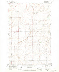
1966 Map of Winchester NE
USGS Topo · Published 1968About this map
The irrigation infrastructure of Grant County's agricultural heartland is the primary focus of this mid-1960s survey. The landscape is defined by the W 20 Canal and a series of technical water-management features, including a prominent Aqueduct and a Siphon near the center of the sheet. These systems, managed by the U.S. Bureau of Reclamation, were critical to transforming the arid terrain into productive farmland. Settlement patterns follow the grid of established routes like Dodson Road and White Trail Road. Local community life is anchored at the Grange Hall, while industrial and utility sites such as a Pumping Station, a Radio Tower, and various Borrow Pits and a Gravel Pit indicate the ongoing development of the area's physical and communication networks during this period.
Find a feature on this map
15 named features on this map. Tap any name to fly to it.
Don’t see what you’re looking for? This feature index may not catch every label — zoom into the map to look around manually.
Map Details
Editions of this 1966 Winchester NE Map
This is the sole edition of this map. No revisions or reprints were ever made.
Other maps of this area

1910 · Winchester
USGS Topo · 1:62,500

1912 · Moses Lake
USGS Topo · 1:62,500

1953 · Ritzville
USGS Topo · 1:250,000

1956 · Ephrata
USGS Topo · 1:62,500

1956 · Ephrata
USGS Topo · 1:24,000

1956 · Ephrata SW
USGS Topo · 1:24,000

1956 · Grant Orchards
USGS Topo · 1:24,000

1956 · Mae
USGS Topo · 1:24,000
1956 · Winchester SE
USGS Topo · 1:24,000

1956 · Winchester NE
USGS Topo · 1:24,000