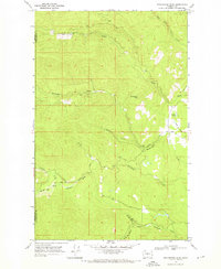
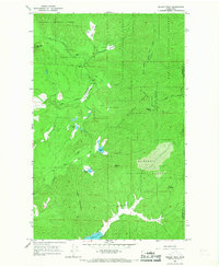
1968 Map of Winchester Peak
USGS Topo · Published 1971About this map
Winchester Peak dominates this high-altitude landscape along the Stevens Co Pend Oreille Co border in the late 1960s. The terrain is defined by a dense network of mountain drainages, including the North Fork Calispell Creek and Middle Fk Calispell Cr, which feed the larger Calispell Creek system. The map documents the primitive transportation network of the era, consisting of specialized routes like the Flowery Winchester Trail, various Jeep Trails, and a Pack Trail. These routes navigate the steep topography between Small Creek and Graham Creek, reflecting a wilderness area primarily utilized for resource management and seasonal access rather than permanent settlement. Knapp Pond provides a rare point of standing water amidst the numerous descending creeks like Dorchester Creek and Gletty Creek.
Find a feature on this map
21 named features on this map. Tap any name to fly to it.
Don’t see what you’re looking for? This feature index may not catch every label — zoom into the map to look around manually.
Map Details
Editions of this 1968 Winchester Peak Map
3 editions found
Other maps of this area

1927 · Chewelah
USGS Topo · 1:125,000

1930 · Chewelah
USGS Topo · 1:125,000

1936 · Newport
USGS Topo · 1:96,000

1942 · Newport
USGS Topo · 1:125,000

1958 · Sandpoint
USGS Topo · 1:250,000

1963 · Sandpoint
USGS Topo · 1:250,000
1964 · Calispell Peak
USGS Topo · 1:24,000

1964 · Goddards Peak
USGS Topo · 1:24,000

1964 · Chewelah Mtn
USGS Topo · 1:62,500
1965 · Nelson Peak
USGS Topo · 1:24,000