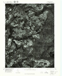
1977 Map of Windber
USGS Topo · Published 1979About this map
Windber and its surrounding coal-country landscapes are captured in high detail through this orthophotograph, produced in cooperation with the Soil Conservation Service. Unlike traditional topographic maps, this aerial imagery reveals the exact footprint of industrial activity and land use in the late 1970s. The dense residential grid of Paint and Windber contrasts sharply with the expansive, disturbed earth of nearby surface operations and the sprawling forested tracts toward Ashtola. Smaller mining settlements like Cairnbrook and Reitz are visible in the southern portion of the sheet, connected by a winding network of roads that follow the difficult contours of the Allegheny Front. The map provides a clear view of the complex relationship between these established company towns and the massive earth-moving projects that defined the regional economy during this era, showing how the patchwork of reclaimed fields and active pits shaped the daily environment of Somerset County residents.
Find a feature on this map
6 named features on this map. Tap any name to fly to it.
Don’t see what you’re looking for? This feature index may not catch every label — zoom into the map to look around manually.
Map Details
Editions of this 1977 Windber Map
This is the sole edition of this map. No revisions or reprints were ever made.
Other maps of this area

1902 · Ebensburg
USGS Topo · 1:62,500

1904 · Ebensburg
USGS Topo · 1:62,500

1904 · Johnstown
USGS Topo · 1:62,500

1907 · Johnstown
USGS Topo · 1:62,500

1908 · Bedford
USGS Topo · 1:62,500

1910 · Bedford
USGS Topo · 1:62,500

1914 · Windber
USGS Topo · 1:62,500

1916 · Windber
USGS Topo · 1:62,500

1944 · Windber
USGS Topo · 1:62,500

1953 · Pittsburgh
USGS Topo · 1:250,000