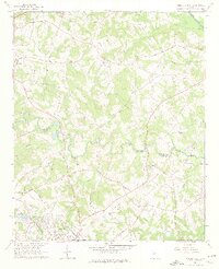
1964 Map of Winder North
USGS Topo · Published 1976About this map
The rolling hills of northeast Georgia are captured here just as the landscape was beginning to transition toward suburban growth, yet still defined by its agrarian roots. The Mulberry River and Middle Oconee River define the local drainage, while the northern edge of Winder and the town of Hoschton anchor the residential development of the early 1960s. Rural life is evidenced by the high density of community centers, including Holsenbeck Sch and numerous country churches like Gum Springs Ch and New Hope Ch.
Find a feature on this map
55 named features on this map. Tap any name to fly to it.
Don’t see what you’re looking for? This feature index may not catch every label — zoom into the map to look around manually.
Map Details
Editions of this 1964 Winder North Map
4 editions found
Other maps of this area

1891 · Gainesville
USGS Topo · 1:125,000

1896 · Monroe
USGS Topo · 1:125,000

1953 · Athens
USGS Topo · 1:250,000

1954 · Greenville
USGS Topo · 1:250,000

1958 · Greenville
USGS Topo · 1:250,000

1958 · Athens
USGS Topo · 1:250,000

1959 · Athens
USGS Topo · 1:250,000

1963 · Athens
USGS Topo · 1:250,000

1964 · Chestnut Mountain
USGS Topo · 1:24,000

1964 · Bold Springs
USGS Topo · 1:24,000