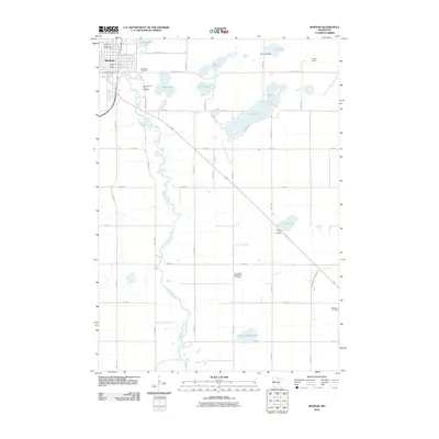
2010 Map of Windom
USGS Topo · Published 2010About this map
The Des Moines River carves a winding path through this portion of Cottonwood County, anchoring the city of Windom. The urban landscape is defined by its civic and community landmarks, including the Windom Post Office and the Cottonwood County Fairgrounds near the shores of Cottonwood Lake. A network of rural cemeteries, such as Saint Francis Xavier Cemetery and the Christiana Norwegian Cemetery, suggests the deep-rooted settlement patterns of the region's early residents.
Find a feature on this map
42 named features on this map. Tap any name to fly to it.
Don’t see what you’re looking for? This feature index may not catch every label — zoom into the map to look around manually.
Map Details
Editions of this 2010 Windom Map
This is the sole edition of this map. No revisions or reprints were ever made.
Other maps of this area

1954 · Fairmont
USGS Topo · 1:250,000

1958 · Fairmont
USGS Topo · 1:250,000

1970 · Jackson NW
USGS Topo · 1:24,000

1970 · Lakefield NE
USGS Topo · 1:24,000
1970 · Bingham Lake
USGS Topo · 1:24,000
1970 · Harder Lake
USGS Topo · 1:24,000

1970 · Wilder
USGS Topo · 1:24,000
1970 · Mountain Lake
USGS Topo · 1:24,000

1970 · Lakefield
USGS Topo · 1:24,000

1970 · Windom
USGS Topo · 1:24,000