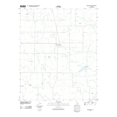
2010 Map of Windthorst
USGS Topo · Published 2010About this map
Windthorst and its surrounding ranchlands are detailed in this 2010 survey, illustrating a landscape defined by North Texas energy production and cattle operations. The map documents numerous petroleum sites including the Scaling Oil Field and the Archer County Regular Oil Field, which punctuate the countryside alongside family-named farm roads. This area is drained by the meandering courses of West Little Post Oak Creek and East Little Post Oak Creek, with water managed at Vieth Lake and the larger Windthorst Lake to the east. Local heritage is centered around Saint Mary Cemetery, while large-scale landholdings like the Bridwell Ranch at the southwestern corner highlight the region's enduring agricultural identity. The grid of rural routes such as Veitenheimer Rd and Munchrath Rd reveals a community where property lines and transport networks have long been intertwined with family history.
Find a feature on this map
38 named features on this map. Tap any name to fly to it.
Don’t see what you’re looking for? This feature index may not catch every label — zoom into the map to look around manually.
Map Details
Editions of this 2010 Windthorst Map
This is the sole edition of this map. No revisions or reprints were ever made.
Other maps of this area

1931 · Archer City
USGS Topo · 1:62,500

1954 · Wichita Falls
USGS Topo · 1:250,000

1958 · Wichita Falls
USGS Topo · 1:250,000

1962 · Windthorst
USGS Topo · 1:24,000

1962 · Antelope Creek NE
USGS Topo · 1:24,000

1963 · Deer Creek
USGS Topo · 1:24,000

1963 · Scotland
USGS Topo · 1:24,000
1963 · Archer City NE
USGS Topo · 1:24,000

1963 · Archer City East
USGS Topo · 1:24,000

1964 · Darnell Branch
USGS Topo · 1:24,000