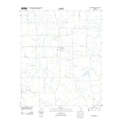
2012 Map of Windthorst
USGS Topo · Published 2012About this map
Windthorst and the surrounding ranching country of Archer County are documented in this 2012 USGS survey, showcasing a landscape defined by petroleum extraction and traditional agriculture. The settlement is anchored by Saint Mary Cem, while the outlying areas are partitioned by a network of rural routes including Munchrath Rd, Pennartz Rd, and Veitenheimer Rd. The region's economic reliance on the energy sector is evident through the extensive footprint of the Archer County Regular Oil Field, Scaling Oil Field, and Transcontinental Oil Field. Hydrology is dominated by the seasonal flow of W Little Post Oak Cr and E Little Post Oak Cr, which feed into the local drainage system alongside Windthorst Lake. To the southwest, the Bridwell Ranch represents the enduring legacy of large-scale Texas landholdings in a territory where industrial oil fields and cattle operations coexist.
Find a feature on this map
43 named features on this map. Tap any name to fly to it.
Don’t see what you’re looking for? This feature index may not catch every label — zoom into the map to look around manually.
Map Details
Editions of this 2012 Windthorst Map
This is the sole edition of this map. No revisions or reprints were ever made.
Other maps of this area

1931 · Archer City
USGS Topo · 1:62,500

1954 · Wichita Falls
USGS Topo · 1:250,000

1958 · Wichita Falls
USGS Topo · 1:250,000

1962 · Windthorst
USGS Topo · 1:24,000

1962 · Antelope Creek NE
USGS Topo · 1:24,000

1963 · Deer Creek
USGS Topo · 1:24,000

1963 · Scotland
USGS Topo · 1:24,000
1963 · Archer City NE
USGS Topo · 1:24,000

1963 · Archer City East
USGS Topo · 1:24,000

1964 · Darnell Branch
USGS Topo · 1:24,000