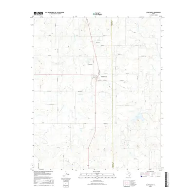
2016 Map of Windthorst
USGS Topo · Published 2016About this map
Windthorst sits at the heart of this North Texas survey, positioned along the dividing line of Archer Co and Clay Co. The landscape is characterized by a network of drainage systems including W Little Post Oak Cr and E Little Post Oak Cr, which feed local reservoirs such as Windthorst Lake and Vieth Lake. Near the town center, the Saint Mary Cem serves as a significant landmark for genealogical research. The map reveals a high density of rural roads named for local families, including Munchrath Rd, Pennartz Rd, and Weinzappel Loop, reflecting the area's deeply rooted agricultural heritage. This road network connects outlying farms to the central settlement and tracks the gradual progression of the terrain toward Darnell Br in the south.
Find a feature on this map
43 named features on this map. Tap any name to fly to it.
Don’t see what you’re looking for? This feature index may not catch every label — zoom into the map to look around manually.
Map Details
Editions of this 2016 Windthorst Map
This is the sole edition of this map. No revisions or reprints were ever made.
Other maps of this area

1931 · Archer City
USGS Topo · 1:62,500

1954 · Wichita Falls
USGS Topo · 1:250,000

1958 · Wichita Falls
USGS Topo · 1:250,000

1962 · Windthorst
USGS Topo · 1:24,000

1962 · Antelope Creek NE
USGS Topo · 1:24,000

1963 · Deer Creek
USGS Topo · 1:24,000

1963 · Scotland
USGS Topo · 1:24,000
1963 · Archer City NE
USGS Topo · 1:24,000

1963 · Archer City East
USGS Topo · 1:24,000

1964 · Darnell Branch
USGS Topo · 1:24,000